 Catalogue PIGMA
Meteorological geographical features
Type of resources
Available actions
Topics
Keywords
Contact for the resource
Provided by
Years
Formats
Representation types
Update frequencies
status
Scale
Resolution
-
-
The National Centers for Environmental Prediction (NCEP) Climate Forecast System (CFS) is initialized four times per day (0000, 0600, 1200, and 1800 UTC). NCEP upgraded their operational CFS to version 2 on March 30, 2011. This is the same model that was used to create the NCEP Climate Forecast System Reanalysis (CFSR), and the purpose of this dataset is to extend CFSR. The 6-hourly atmospheric, oceanic and land surface analyzed products and forecasts, available at 0.2, 0.5, 1.0, and 2.5 degree horizontal resolutions, are archived here beginning with January 1, 2011 as an extension of CFSR.
-
The SMOS Level-4 SMAP Compatible Brightness Temperatures (BT) product provides an unbiased version of the SMOS Level-3 BT with respect to the SMAP Enhanced Level-3 BT. This data set is self-sufficient but it can also be used along with the SMAP Level-3 Enhanced BT for applications for which spatial coverage and revisit frequency of the BT measurements are essentials.
-
BLACKSEA_CH01_Product_03 / Assessment of the confidence limits of the data sets for the test regions
Assessment of the confidence limits of the data base by means of evaluation of the two involved numerical models: The wave model WAM (Parameter: Significant wave height Hs) and the Atmospheric model SKIRON (Parameter: Wind Speed 10m)
-
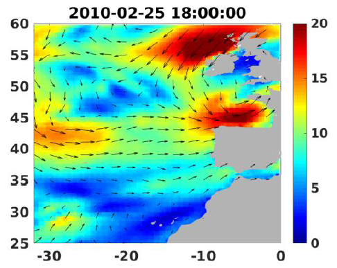
Wind analyses, estimated over the North Atlantic Ocean with a focus on some specific regions, are one the main ARCWIND (http://www.arcwind.eu/) project deliverables. They are estimated from various remotely sensed wind observations in combination with numerical model (WRF), with regular space (0.25deg in latitude and longitude), and time (00h:00, 06h:00, 12h:00, 18h:00 UTC), and based the method described in (Bentamy A., A. Mouche, A. Grouazel, A. Moujane, M. A. Ahmed. (2019): Using sentinel-1A SAR wind retrievals for enhancing scatterometer and radiometer regional wind analyses . International Journal Of Remote Sensing , 40(3), 1120-1147 . https://doi.org/10.1080/01431161.2018.1524174).
-
Assessment of the confidence limits of the data base by means of evaluation of the two involved numerical models: The wave model WAM (Parameter: Significant wave height Hs) and the Atmospheric model SKIRON (Parameter: Wind Speed 10m)
-
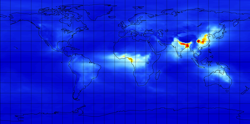
M2TMNXAER (or tavgM_2d_aer_Nx) is a time-averaged 2-dimensional monthly mean data collection in Modern-Era Retrospective analysis for Research and Applications version 2 (MERRA-2). This collection consists of assimilated aerosol diagnostics, such as column mass density of aerosol components (black carbon, dust, sea salt, sulfate, and organic carbon), surface mass concentration of aerosol components, and total extinction (and scattering ) aerosol optical thickness (AOT) at 550 nm. The total PM1.0, PM2.5, and PM10 may be derived with the formula described in the FAQs under the Documentation tab of this page. The collection also includes variance of certain parameters. MERRA-2 is the latest version of global atmospheric reanalysis for the satellite era produced by NASA Global Modeling and Assimilation Office (GMAO) using the Goddard Earth Observing System Model (GEOS) version 5.12.4. The dataset covers the period of 1980-present with the latency of ~3 weeks after the end of a month.
-
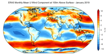
ERA5 is the fifth generation ECMWF reanalysis for the global climate and weather for the past 4 to 7 decades. Currently data is available from 1950, split into Climate Data Store entries for 1950-1978 (preliminary back extension) and from 1979 onwards (final release plus timely updates, this page). ERA5 replaces the ERA-Interim reanalysis. Reanalysis combines model data with observations from across the world into a globally complete and consistent dataset using the laws of physics. This principle, called data assimilation, is based on the method used by numerical weather prediction centres, where every so many hours (12 hours at ECMWF) a previous forecast is combined with newly available observations in an optimal way to produce a new best estimate of the state of the atmosphere, called analysis, from which an updated, improved forecast is issued. Reanalysis works in the same way, but at reduced resolution to allow for the provision of a dataset spanning back several decades. Reanalysis does not have the constraint of issuing timely forecasts, so there is more time to collect observations, and when going further back in time, to allow for the ingestion of improved versions of the original observations, which all benefit the quality of the reanalysis product. ERA5 provides hourly estimates for a large number of atmospheric, ocean-wave and land-surface quantities. An uncertainty estimate is sampled by an underlying 10-member ensemble at three-hourly intervals. Ensemble mean and spread have been pre-computed for convenience. Such uncertainty estimates are closely related to the information content of the available observing system which has evolved considerably over time. They also indicate flow-dependent sensitive areas. To facilitate many climate applications, monthly-mean averages have been pre-calculated too, though monthly means are not available for the ensemble mean and spread. ERA5 is updated daily with a latency of about 5 days (monthly means are available around the 6th of each month). In case that serious flaws are detected in this early release (called ERA5T), this data could be different from the final release 2 to 3 months later. So far this has not been the case and when this does occur users will be notified. The data set presented here is a regridded subset of the full ERA5 data set on native resolution. It is online on spinning disk, which should ensure fast and easy access. It should satisfy the requirements for most common applications. An overview of all ERA5 datasets can be found in this article. Information on access to ERA5 data on native resolution is provided in these guidelines. Data has been regridded to a regular lat-lon grid of 0.25 degrees for the reanalysis and 0.5 degrees for the uncertainty estimate (0.5 and 1 degree respectively for ocean waves). There are four main sub sets: hourly and monthly products, both on pressure levels (upper air fields) and single levels (atmospheric, ocean-wave and land surface quantities). The present entry is "ERA5 monthly mean data on single levels from 1979 to present".
-

-